Summary - This traverse starts from the Silver Star trailhead (45.78080, -122.24362) and links Silver Star Mountain with 3977 (Discriminator). Covering roughly 8.5 miles and 2800 ft of elevation gain, it has amazing views, some steep sections, and a bit of scrambling. Do 3977 first to get the toughest part of the hike behind you, enjoy the big views on Silverstar and have a mostly downhill walk back to the trailhead. From SE Portland to the trailhead is about ninety minutes. Caution advised when planning the drive: FR41 is not Prius-friendly.
Activation Reports

Submitted by K7WXW on
Summit:
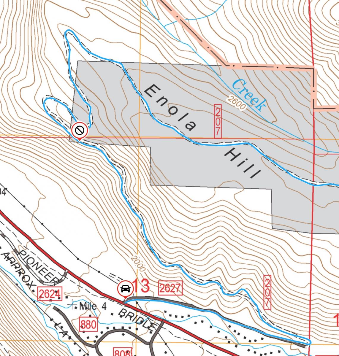
Zigzag Mountain Road, aka Road 27, aka FR2627 is the access road to the Zigzag, West Zigzag, and other trailheads west of Mount Hood. The Forest Service road crosses two parcels of privately owned land and the owner has put a locked gate and no trespassing signs up at (45.32085, -121.89377), blocking accesss. Below you will find a couple of things you can do about this gate. Here is a map showing the location:

Submitted by KG7WED on
Summit:
Have your recent SOTA activations been way too easy? Does walking on trails bore you? Do you want to earn the Most Calories Burned Per SOTA Point award*? Then have I got the peak for you!

Submitted by K7AGL on
Summit:
I was surprised to find an accessible peak in CM that the Bend SOTA folks had not yet activated. I did the activation as a snowshoe, but you can drive up a lot closer to the summit if there is no snow. As you ascend, the forest growth increasingly closes in, so basically, just park when you can't take any more scratching up of your paint. It is a very pleasant 2.8 mile hike from the main road. I've posted a GPX track you can download. I posted summit pics to SOTA Atlas.

Submitted by K7ATN on
Summit:
The "easy to reach" Grassy Knob near Port Orford, Oregon is not a summit. Elevation: 2,342' Rise: 442' While the Grassy Knob Wilderness HP about four miles east is W7O/SC-302 and looks like a daunting wilderness bushwhack. Elevation: 2,620' Rise: 880'

Submitted by AE7AP on
Summit:
This summit is a drive-up. The summit is a fantastically beautiful flower-covered meadow with views in all directions. The road is suitable for a Rav4, Subaru, etc., but one may have to go slowly due to some full-width potholes. With a higher clearance vehicle (e.g. 4-Runner), it is fast and easy. The potholes were full of water in late May, but none were muddy or super deep.
Submitted by K7WXW on
Summit:
Summary - This is another one of my traverse hikes, linking 4180 (LC-071) and Big Huckleberry (LC-069) over the Pacific Crest Trail in the GPNF. After a ninety minute drive (with a toll bridge) from Portland to the trailhead, you'll find both an easy forest road hike and bushwhack to the summit of 4180 and a PCT hike over to Big Huckleberry. You will cover about eleven miles with 1700 feet of gain, do an easy if steep bushwhack on 4180 bushwhack, and collect big views on Big Huck.

Submitted by WJ7V on
Summit:
NOTE: This area may have burned in July 2025. If anyone has intel, please post. I believe it may have just been the western approach side of the mountain.
Aubrey Mountain is 2 point summit near Oakridge, OR in the Willamette National Forest. The summit can be accessed either from a neighborhood at the edge of town or from a higher trailhead on the northeast side. I took the high road as described below:
Submitted by WJ7V on
Summit:
Johnson Mountain is a 2 point summit near Powers, OR in the Rogue/Siskiyou National Forest. This site is the presumed location of a famous meteorite hoax detailed here. Due to a closure of Johnson Mountain Road out of Powers, we were advised to head south to China Flat campground which is a good route (detailed below).